


FREEWAT
H2020 project

Project start: April 2015
Project end: September 2017
METCENAS contact person:

RNDr. Zuzana BOUKALOVÁ
Coordinator:
 | Scuola Superiore Sant'Anna, Italy |
Partners:
 | Tea Sistemi SpA, Italy | |
 | Technische Universität Darmstadt, Germany | |
 | Sc Institute of Environmental Assessment and Water Research, Spain | |
 | Oslandia, France | |
 | UNESCO, France | |
 | Regione Toscana, Italy | |
| | METCENAS, Czech Republic | |
 | Zeta Amaltea, Spain | |
| | Institut za ekološki inženiring, Slovenia | |
 | Erciyes University, Turkey | |
 | Lavrion Technological and Cultural Park, Greece | |
 | Institutul National de Hidrologie si Gospodarire a Apelor, Romania | |
 | Department of Geology University of Tartu, Estonia | |
 | Taras Shevchenko National University of Kyiv, Ukraine | |
 | Paragon Europe, Malta | |
 | University of Bremen, Germany |
FREEWAT: FREE and open source software tools for WATer resource management
Call: H2020-WATER-2014-one-stage
Topic: WATER-4a-2014
Type of Action: CSA
Proposal number: SEP-210140754
Project duration: 1. 4. 2015 – 30. 9. 2017 (30 months)
Coordinator:
Scuola Superiore di Studi Universitari di Perfezionamento Sant'Anna (Itálie)
Totally 17 international Partners – Partner n. 8: METCENAS (Leader of WP 6)
The project is built from eight work packages:
WP1: Project management
WP2: Software integration and customisation
WP3: Capacity building
WP4: Application to WFD/GWD
WP5: Application to water rural management
WP6: Enhanced science- and participatory approach evidence-based decision making
WP7: Guidance on model-supported application of EU water related Directives for water quantity and quality
WP8: Dissemination and Exploitation and Communication
FREEWAT (FREE and open source software tools for WATer resource management) is a EU HORIZON 2020 project aiming at promoting the application of EU water-related Directives by means of an open source and public domain, GIS-integrated solution for planning and management of surface- and ground-water resources, along with dedicated participatory approach.
The FREEWAT platform is at present a large QGIS (https://www.qgis.org/en) plugin, allowing to couple the power of GIS geo-processing and post-processing tools in spatial data analysis with that of process-based simulation models. As such, the FREEWAT platform is conceived as a canvas, where several simulation codes, based on the hydrological cycle, hydrochemical or economic-social processes, are virtually integrated and input and output data is managed through a SpatiaLite Data Base Management System.
The FREEWAT platform is designed for water authorities and public/private companies to build a high informative and dynamically growing representation of hydrologic systems. Policy makers may benefit from its application to produce scientifically and technically sounding decision and policy making adopting a participatory approach, by involving stakeholders (e.g., in the formation of River Basin Management Plans, as required by the Water Framework Directive) not only in the final stage of result discussion, but also during the phase of scenario definition.
FREEWAT capabilities
The FREEWAT platform includes the following modules for pre-processing and model implementation.
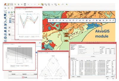
AkvaGIS provides several pre-processing tools for the analysis and interpretation of hydrochemical and hydrogeological data. The capabilities of the akvaGIS module span from plots and statistics related to hydrochemical data for groundwater quality assessment to interpretation of hydrogeological data and generation of thematic maps for implementation of conceptual models.
Observation Analysis Tool (OAT) is a pre-processing tool to provide the User with enhanced time-series processing capabilities, in the view of an increasing establishment of diffuse, online and real-time monitoring networks. OAT is designed to facilitate the import, analysis and visualization of time-series data and the use of these data to support model construction and advanced model calibration.
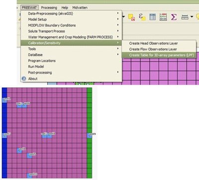
Groundwater flow simulation in aquifers may be performed using MODFLOW-2005, a physically-based, spatially distributed code developed by the USGS, which simulates the groundwater flow dynamics in the saturated and unsaturated zones. Flow associated to wells, areal recharge, evapotranspiration, drains, and rivers, can be simulated through specific MODFLOW Packages, among which the Lake Package is worth of mention for the simulation of lake-aquifer interaction.
In FREEWAT, the hydrological model can be coupled with a solute transport model, to simulate multispecies advective-dispersive transport, both in unsaturated and saturated zone, using MT3DMS. The possibility to simulate viscosity- and density-dependent flows is available as well through the application of SEAWAT. Such capabilities are particularly relevant to approach seawater intrusion processes or to assess geothermal plants at low and medium enthalpy.
Sustainable water management is accomplished by the Farm Process integrated within MODFLOW-OWHM (One-Water Hydrologic Flow Model; USGS), which is the most current version of MODFLOW. The Farm Process allows to dynamically simulate demand and supply components of water use for basic units of water consumption under demand-driven and supply-constrained conditions.
A fully-coupled, integrated hydrologic model is so obtained, with estimation of water allocations from conjunctively used surface- and ground-water and with focus on rural water management.
The module for sensitivity analysis and parameter estimation is based on UCODE_2014 and aims at improving the model fit, by reducing the gap between model-simulated heads and flows and the observed data. To accomplish this task, several statistics can be used to evaluate model construction and to select parameters to be estimated through an inverse, regression method based on the evaluation of an objective function.
Training and application of the platform
The FREEWAT platform comes along with a set of tutorials and 6 User Manuals. These tutorials include the following material: (i) 3 tutorials about the application of MODFLOW-2005 to simulate the groundwater dynamics, (ii) 2 lectures reporting the basic concepts of MODFLOW, and (iii) one lecture about the use of GGIS (Global Groundwater Information System) and GGMN (Global Groundwater Monitoring Network).
Further to this, tutorials and handouts for each of the aforementioned modules are available.
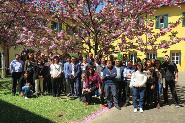
To disseminate the use of the FREEWAT platform as a standard software for modeling surface/sub-surface water quantity and quality dynamics, about 100 persons from 60 institutions were trained up to July 2016.
On July 31st 2016, version 0.1 of the FREEWAT platform was released. The current version is version 0.5.
The FREEWAT platform is under testing and will be applied to 14 case studies in EU and non-EU Countries, to address specific water management issues.
A second round of training will soon start before FREEWAT public release by September 2017. Participation is free and remote support is guaranteed.
If you wish to be included or simply you wish to be updated about FREEWAT outcomes, please write an e-mail to r.rossetto@santannapisa.it.
Project coordinator
Dr. Rudy Rossetto
Institute of Life Sciences
Scuola Superiore Sant'Anna, Pisa (Italy)
e-mail: r.rossetto@santannapisa.it
Phone: +39 050 883 506